


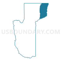
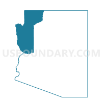
Moccasin Voting District, Mohave County, Arizona
About
Outline

Summary
| Unique Area Identifier | 525066 |
| Name | Moccasin Voting District |
| County | Mohave County |
| State | Arizona |
| Area (square miles) | 1,198.45 |
| Land Area (square miles) | 1,197.71 |
| Water Area (square miles) | 0.74 |
| % of Land Area | 99.94 |
| % of Water Area | 0.06 |
| Latitude of the Internal Point | 36.63904610 |
| Longtitude of the Internal Point | -112.83754390 |
Maps

Graphs
Select a template below for downloading or customizing gragh for Moccasin Voting District, Mohave County, Arizona


Neighbors
Neighoring Voting District (by Name) Neighboring Voting District on the Map
- Colorado City Voting District, Mohave County, AZ
- Fredonia Voting District, Coconino County, AZ
- Havasupai Voting District, Coconino County, AZ
- Kanab 3 Unincorporated Voting District, Kane County, UT
- Kanab 4 Incorporated 1 Voting District, Kane County, UT
- Kanab 4 Unincorporated 1 Voting District, Kane County, UT
- Littlefield Voting District, Mohave County, AZ
- North Rim Voting District, Coconino County, AZ
- Outside Apple Valley #AV51.5 Voting District, Washington County, UT
- Paiute Voting District, Coconino County, AZ
Top 10 Neighboring County Subdivision (by Population) Neighboring County Subdivision on the Map
- Hurricane CCD, Washington County, UT (25,701)
- North Mohave CCD, Mohave County, AZ (10,851)
- Williams CCD, Coconino County, AZ (10,435)
- Kanab CCD, Kane County, UT (5,697)
- Kaibab Plateau CCD, Coconino County, AZ (2,037)
- Hualapai CCD, Coconino County, AZ (6)
Top 10 Neighboring Place (by Population) Neighboring Place on the Map
- Colorado City town, AZ (4,821)
- Fredonia town, AZ (1,314)
- Centennial Park CDP, AZ (1,264)
- Cane Beds CDP, AZ (448)
- Kaibab CDP, AZ (124)
- Moccasin CDP, AZ (89)
Top 10 Neighboring Unified School District (by Population) Neighboring Unified School District on the Map
- Washington School District, UT (138,115)
- School District Not Defined, AZ (69,809)
- Kane School District, UT (7,125)
- Colorado City Unified District, AZ (6,133)
- Fredonia-Moccasin Unified District, AZ (2,825)
Top 10 Neighboring State Legislative District Lower Chamber (by Population) Neighboring State Legislative District Lower Chamber on the Map
- State House District 3, AZ (216,687)
- State House District 2, AZ (177,904)
- State House District 73, UT (34,070)
Top 10 Neighboring State Legislative District Upper Chamber (by Population) Neighboring State Legislative District Upper Chamber on the Map
- State Senate District 3, AZ (216,687)
- State Senate District 2, AZ (177,904)
- State Senate District 28, UT (94,905)
Top 10 Neighboring 111th Congressional District (by Population) Neighboring 111th Congressional District on the Map
- Congressional District 2, AZ (972,839)
- Congressional District 2, UT (890,993)
- Congressional District 1, AZ (774,310)
Top 10 Neighboring Census Tract (by Population) Neighboring Census Tract on the Map
- Census Tract 9501, Mohave County, AZ (10,851)
- Census Tract 2701, Washington County, UT (8,839)
- Census Tract 23, Coconino County, AZ (6,674)
- Census Tract 1302, Kane County, UT (4,828)
- Census Tract 1301, Kane County, UT (2,297)
- Census Tract 20, Coconino County, AZ (2,037)
Top 10 Neighboring 5-Digit ZIP Code Tabulation Area (by Population) Neighboring 5-Digit ZIP Code Tabulation Area on the Map
- 86021, AZ (6,085)
- 84741, UT (5,556)
- 86432, AZ (3,933)
- 84784, UT (2,745)
- 86022, AZ (2,210)
- 84767, UT (679)
- 86435, AZ (487)
- 86052, AZ (28)